Fortress Rosecrans
|
Fortress Rosecrans (1863-1866) - A Union U.S. Civil War fortress first established in 1863 in present day Murfreesboro, Rutherford County, Tennessee. Named Fortress Rosecrans after General William S. Rosecrans, (Cullum 1115), Commander of the Army of the Cumberland. The fortress was abandoned in 1866 after the end of the war.
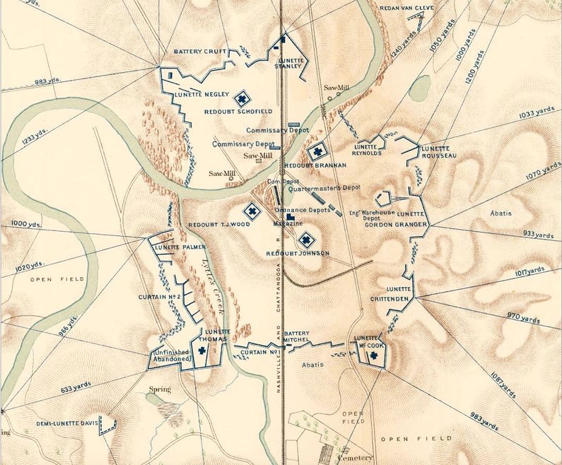
History of Fortress RosecransFortress Rosecrans was a very large bastioned earthworks fortification begun 23 Jan 1863 after the Battle of Stones River. Constructed by the Pioneer Brigade under the direction of Brigadier General USV, James St. Clair Morton, (Cullum 1495). The fortress was mostly complete in June 1863 when General Rosecrans and his army departed the area leaving the fortress manned by new recruits and convalescing troops. The fortress was located at a strategic road junction of the Nashville Turnpike and the Wilkerson Turnpike and sat astride the Nashville and Chattanooga Railroad tracks. The Stones River ran right through the fortress. The fortress became a major logistical hub for Union armies in this part of the country. As one of the largest earthworks fortifications built during the U.S. Civil War, the fortress contained numerous named fortified elements including four redoubts, nine lunettes, two demilunettes, one redan and two batteries enclosed in a 225 acre reservation. A tenth lunette (Lunette Sheridan) is shown on some maps as being located on the high ground behind Lunette Gordon Granger. The earthen walls surrounding the fortress were ten to fifteen feet high fronted by a ten foot deep ditch filled with sharpened stakes. The fortress was never directly attacked. Housed within the fortification was a large logistics operation that included warehouses, three commissary depots, a quartermaster depot, two ordnance depots and a large "L" shaped magazine. This main magazine was located between three protective redoubts (Redoubt Brannan, Redoubt Johnson and Redoubt T.J. Wood). The fortress also contained four steam powered sawmills that supplied the command with lumber for building and railroad construction. The rail line through the fortress was the primary method for receiving and distributing supplies and material to forward elements of the army. As the war progressed the fortress was used as a convalescing hospital for sick and injured troops as well as injured horses and mules. Able-bodied troops were increasing shipped to more active fronts and the convalescing troops were counted as a part of the defending garrison should an attack take place. An inspection report dated 14 Jan 1864 indicated that the fort was manned by the 1st Kentucky Battery and about 800 convalescent officers and soldiers all commanded by Major Charles Houghtaling, 1st Illinois Light Artillery. At the end of the war in 1865 the earthworks had already deteriorated to the point where some of the redoubt parapets had settled to a 45 degree slope and the parapets of the main line had started to fall. The fortress remained open until April of 1866 when it was abandoned by the Army.
Current StatusNow a unit of Stones River National Battlefield. Visible remains at three locations:
Much of the remainder of the fortress has been overbuilt by modern development.
See Also: Sources:
Visited: 16 May 2016
| ||||||||||||||||
