Klamath Air Force Station
|
Klamath Air Force Station (1950-1981) - A Cold War Air Force Radar Station first established in 1950 near Klamath, Del Norte County, California. Named Klamath Air Force Station after the location. Initially assigned a Lashup-Permanent ID of LP-33, later a Permanent ID of P-33, a Sage ID of Z-33 and finally a JSS ID of J-83. Manned by the 777th AC&W Squadron later became the 777th Radar Squadron (SAGE). Deactivated as a USAF facility in 1981 and turned over to the National Park Service and the FAA. The FAA continued operation of the site until 1997 as Crescent City FAA Radar Site. Also known as Requa Air Force Station.
HistoryEstablished in 1950 and became operational in April 1952 as Klamath Air Force Station manned by the 777th AC&W Squadron. The station initially had both a Ground-Control Intercept (GCI) and an early warning mission. The early warning mission involved tracking and identifying all aircraft entering their airspace while the GCI mission involved guiding Air Force interceptors to any identified enemy aircraft. Controllers at the station vectored fighter aircraft at the correct course and speed to intercept enemy aircraft using voice commands via ground-to-air radio. The U.S. Army Corps of Engineers (USACE) provides a slightly different view of the site name and origins:
The Lashup-Permanent site operated the outdated TPS-1B combination search and height-finder radar as early as April 19. The permanent site's initial equipment included the FPS-3 search radar and FPS-4 height-finder radar became operational in April 1952. In 1956 a GPS-3 was added to the facility. By 1958 the configuration included an FPS-20A search radar and an FPS-6 height finder. In 1959 an FPS-6A height-finder radar was added, and that established the initial configuration for SAGE operation, one long-range search radar, and two height-finders. SAGE TransitionThe transition of the manual GCI system to the automated SAGE system began with the installation of the FST-2 coordinate data transmitter and search radar upgrades. The FST-2 equipment digitized the radar returns and transmitted the digital returns to the SAGE direction center. Under the SAGE System, interceptor aircraft were directed to their targets by the direction center computers and controllers, greatly reducing the need for local controllers and equipment at every radar station. The FST-2 was a very large digital system using vacuum tube technology. Over 6900 vacuum tubes were used in each FST-2 requiring 21 air-conditioned cabinets, 40 tons of air conditioning, 43.5 kva of prime power, and usually a large new addition to the operations building. The FST-2B modification added two more cabinets but with newer solid-state (transistor) technology to process coded responses from aircraft transponders. SAGE System Operation The site began operation as a SAGE System radar site in 1960 initially feeding the Adair SAGE Direction Center DC-13.
By the end of 1961, the FPS-20A had been upgraded and redesignated as an FPS-66. By 1966 there was an FPS-27 long-range search radar in place, and a FPS-26A height-finder radar in operation there. A FYQ-47 Common Digitizer was probably placed in service by February 1973 when the USAF/FAA FST-2 to FYQ-47 replacement program was completed. Site radar operation was taken over from USAF by FAA in 1978. The site came under TAC jurisdiction beginning in 1979. ClosureKlamath AFS and the 777th were deactivated on 30 Sep 1981. Forty-one acres of the property were turned over to the National Park Service (NPS) by the GSA on 10 Mar 1983. Two acres surrounding the FPS-27 radar tower were transferred to the Federal Aviation Administration (FAA) as a Joint Surveillance System (JSS) site. The FAA renamed the new facility as Cresent City FAA Radar Site. Some specific functions, including height-finder operations and the GATR site, were continued by Air Force personnel operating as an Operating Location (OL). The last Air Force personnel reportedly left the site in 1990. Crescent City FAA Radar SiteIn 1979 the FAA assumed operation of the site as a JSS site and the FPS-27A search radar was removed and replaced with an FPS-64A search radar intended for unattended operation. In 1981 the two acres around the old FPS-27 tower were transferred to the FAA. Included in the transfer were several buildings including building #98 the former FPS-27 tower, an admin building #106, a service garage building #102 (old Powerhouse), and two concrete slabs. Building #106 became an FAA dorm and the old powerhouse became an FAA garage and storage building. A FYQ-47 Common Digitizer was probably placed in service by February 1973 when the USAF/FAA FST-2 to FYQ-47 replacement program was completed. By 1990 the site was equipped with an FPS-66A search radar and a CD-2A Common Digitizer. The Crescent City CD-2A was scheduled to receive an upgrade kit to implement three-level weather data processing in May 1992. The radar site data was available to the USAF/NORAD operations centers at McChord AFB and Luke AFB as well as the FAA Seattle ARTCC (ZSE), Oakland ARTCC (ZOA), and adjacent ARTCCs. The Crescent City FAA Radar Site continued in operation until the FAA/USAF joint-use Rainbow Ridge FAA Radar Site (J-83A), with its then state-of-the-art ARSR-4 radar, was operational on 30 Jun 1997. Gap FillersKlamath AFS was responsible for the maintenance of one remote unattended gap-filler radar site. The unattended gap filler sites were placed in locations where the main search radar lacked coverage. These sites were equipped with short range FPS-14 or FPS-18 search radars and FST-1 Coordinate Data transmitters that sent digitized radar target data to a SAGE direction center and to the main radar site. Both the radar set and the FST-1 were dual channel to increase site up time. Maintenance teams were dispatched for regularly scheduled maintenance or when fault indicators on the FSW-1 remote monitoring equipment suggested the site had problems. The FSW-1 also allowed remote operation of specific functions such as channel changes for the radar and for the FST-1, it also allowed remote operation of the diesel generators at the gap filler site. The Klamath AFS gap-filler radar was located at Capetown, California.
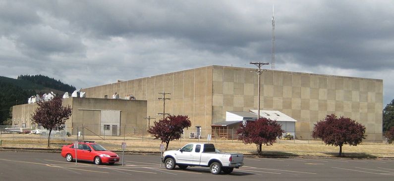
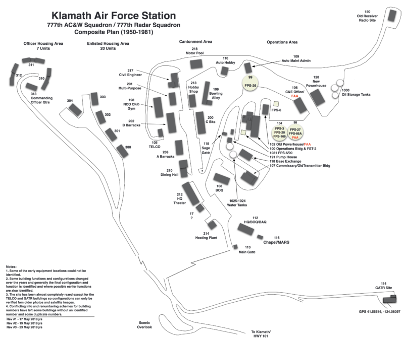
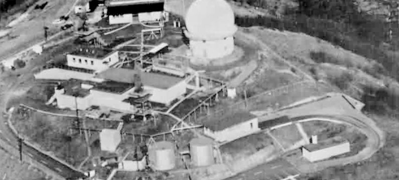
Physical Plant The geography of Klamath AFS dictated a number of unusual features for this type of radar site. The hilly terrain and lack of contiguous flat space resulted in the construction of two separate housing areas and the construction of multi-family housing. The physical plant of the site was divided into a small hilltop main operations area, a lower cantonment area, two housing areas, and three radio sites. The main operations area housed the operations buildings, the radar towers, and the backup generators. The Cantonment area housed the enlisted barracks, the bachelor officer's quarters, the orderly room, the dining hall, the motor pool, and other support buildings. Apart from the main site were the two housing areas for married personnel. The housing areas had five, fourplex buildings for enlisted family quarters, three duplex officer's quarters, and the commanding officer's single quarters for a total of 27 housing units. Separate roads led from the housing areas to a common junction with the road to the cantonment area but there was not a direct road from the housing areas to the cantonment area. A separate radio site housed the radio equipment for directing aircraft intercepts. Like most early radar stations, Klamath originally had a radio transmitter site and a separate radio receiver site used by local controllers for voice direction of fighter interceptors to their targets. With the SAGE System, the SAGE Direction centers had the primary task of directing intercepts and the local radio sites were reconfigured, usually into a single site that was known as the Ground to Air Transmitter Receiver (GATR) site. The GATR site communicated with the interceptors from either the local site or the SAGE direction center via voice commands and/or a digital data link. The Klamath GATR site was consolidated into the former receiver site located in a separate fenced compound about 1/4 mile southeast of the operations area. The vacant transmitter building became the commissary building after modifications and additions.
|
||||||||||||||||||||||||||||||||||||||||||||||||||||||||||||||||||||||||||||||||||||||||||||||||||||||||||||||||||||||||||||||||||||||||||||||||||||||||||||||||||||||||||||||||||||||||||||||||||||||||||||||||||||||||||||||||||||||||||||||||||||||||||||||||||||||||||||||||||||||||||||||||||||||||||||||||||||||||||||||||||||||||||||||||||||||

