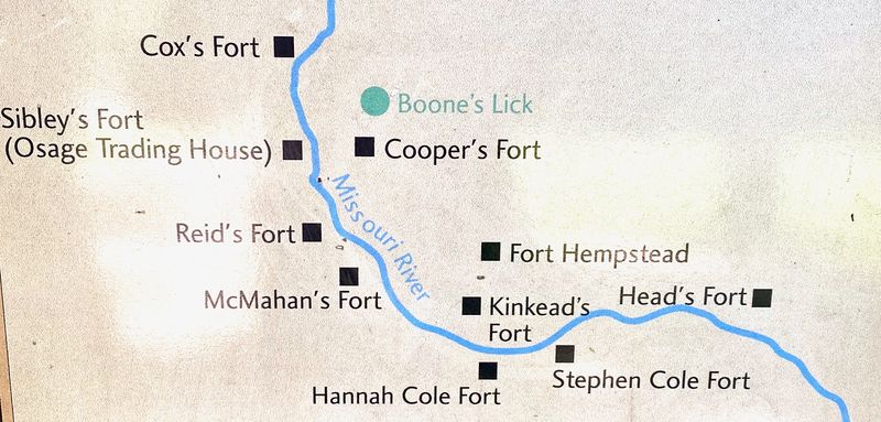
Stephen Cole's Fort
| More information at Warlike, Wikidata, Wikipedia
HistoryAt the outbreak of the War of 1812 the settlers around Boonesboro, Missouri began construction of forts as refuges from British sponsored hostile Indian attacks. The settlers were spread out in farms along a fertile plain on the north side of the Missouri River and in small settlements on the south side so many forts were required to provide safety for all. In all, some 500 to 600 persons gathered in these forts for protection. At the west end of the plain was the economic engine of the area, the Boone's Lick salt works. Boone's Lick was named after the sons of Daniel Boone and was in fact a series of saltwater springs. The saltwater was boiled down to produce salt crystals which were packaged and shipped to St. Louis at a profit. The Indian attacks became so severe by 1814 that the salt works were shut down until 1815 when peace was made with the warring Indian tribes.  North Side of River
South Side of River
On the south side of the Missouri River, the first fort erected was Stephen Cole's Fort, which was reportedly located in the "Old Fort Field", about one and one-half miles east of the present site of Booneville, north of the Boonville and Rocheport road. Another account places it one mile from the new fort (Hannah Cole's Fort) on a bluff near the river. When Stephen Cole and his neighbors completed the erection of the fort, all the families living around, especially on the south side of the river, gathered at his fort for protection from the Indian raiders. Stephen Cole's Fort consisted of a stockade flanked by log cabins where settler families lived during most of the War of 1812. Their food consisted almost entirely of wild game and fish caught from the river. Hunting parties were sent out almost daily. A few months after Cole's Fort was completed a band of about 400 Indians appeared near the fort but did not attack it. There were only six men at the fort because two hunting parties were out after game. One pair of hunters on their return encountered the band of Indians and attempted to break through to the fort. One of the hunters was severely wounded and knowing that he could not make it to the fort passed his gun to his companion and told him to save himself. The uninjured hunter made it into the fort but the other was scalped by the Indians who then mutilated his body. The Indians had not yet fired upon the fort and the defenders did not wish to start a fight they could not win so they held their fire. By the following day, the hunters and the remaining settlers who were outside the fort had reached the fort and the standoff continued. On the next day, a keelboat loaded with trading goods and containing 25 kegs of powder, 400 pounds of musket balls, and a keg of whiskey attempted to pass the fort. The keelboat was commanded by a Captain Coursault and it belonging to French traders in St. Louis who were shipping the goods and ammunition for the Indian trade. The boat was stopped and commandeered by the fort's defenders who used it to transport themselves and all their household goods across the river to Fort Kincaid and Fort Hempstead on the north side leaving their own fort empty. Captain Coursault was then permitted to take his boat back to St. Louis, minus the ammunition and whiskey and it was made clear to him not to trade with the Indians. Stephen Cole's Fort was later reoccupied in the spring of 1813 and served as a refuge for the south side settlers until the very last month of the war with the British. In December 1814 the brutal slaying of Samuel McMahan caused the settlers to build a larger and stronger fort on Hannah Cole's land and all the settlers moved into the new fort. The Indians continued to prosecute their own war on the settlers until the summer of 1815. Current StatusUnknown
See Also:
Sources:
Links: Visited: 20 Aug 2020 Area
|