McMahan's Fort
|
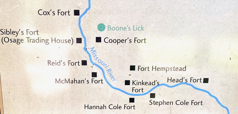
HistoryAt the outbreak of the War of 1812 the settlers around Boonesboro, Missouri began construction of forts as refuges from British sponsored hostile Indian attacks. The settlers were spread out in farms along a fertile plain on the north side of the Missouri River and in small settlements on the south side so many forts were required to provide safety for all. In all, some 500 to 600 persons gathered in these forts for protection. At the west end of the plain was the economic engine of the area, the Boone's Lick salt works. Boone's Lick was named after the sons of Daniel Boone and was in fact a series of saltwater springs. The saltwater was boiled down to produce salt crystals which were packaged and shipped to St. Louis at a profit. The Indian attacks became so severe by 1814 that the salt works were shut down until 1815 when peace was made with the warring Indian tribes.  North Side of River
South Side of River
A settler fort probably erected in 1812 (or 1813), this Indian defense was located on the south side of the Missouri River, Lamine Township, south of Cooper's Fort and south of Arrow Rock. William McMahan served as a First Lieutenant in Sarshall Cooper's company of 112 rangers. In 1814 Some fourteen families lived at or near this fort when a large group of Indians appeared at the fort. The settlers all fled across the Missouri River to Cooper's Fort carrying their household goods with them but by necessity leaving their livestock and horses behind. The Indians camped by the fort, burned it, and John McMahan’s house down, stole 66 horses, and destroyed the cattle, sheep, and corn. Most settlers did not return after the Indians finally left some two weeks later and the Fort was not rebuilt. The War of 1812 ended in December 1814 but hostilities with the Indians continued into 1815. Current StatusThe exact site is not known and the coordinates presented here represent a guess as to the approximate location. Said to be about five miles from Cooper's Fort and in Lamine Township. No known markers.
See Also: Sources:
Links:
Visited: 20 Aug 2020 Area
|