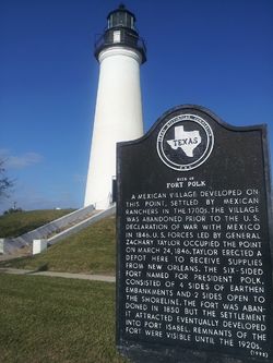
Fort Polk (1)
|
Fort Polk (1846-1850) - A U.S. Army post established on 24 Mar 1846 during the Mexican War by General Zachary Taylor at Port Isabel, Texas. Taylor erected a depot here to receive supplies from New Orleans. The Fort was named for then-President James K. Polk (1845–1849). Abandoned in 1850. HistoryA Mexican village developed on this point, settled by Mexican ranchers in the 1700s. The village was abandoned prior to the U.S. Declaration of war with Mexico in 1846. U.S. forces led by General Zachary Taylor occupied the point on 24 Mar 1846. Taylor erected a depot here to receive supplies from New Orleans. The six-sided Fort, named for President Polk, consisted of 4 sides of earthen embankments and 2 sides open to the shoreline. The fort included one of the largest military hospitals in the United States. Fort Polk was garrisoned from 1848 until 1850 by Captain Franklin E. Hunt's (Cullum 560) company of the 4th U.S. Artillery regiment. By January 1849 the buildings were being moved to different locations on the Rio Grande. On February 9, 1850, the post was abandoned but the settlement it attracted eventually developed into Port Isabel. The location was used as a transit depot for materials for Fort Brown 91) in 1852, and on February 21, 1861, at the outbreak of the U.S. Civil War, it was seized by a Confederate artillery company from Galveston. Famous individuals including Ulysses S. Grant (Cullum 1187), Robert E. Lee (Cullum 542), and other notable men were stationed at this fort. Current Status Remnants of the Fort were visible until the 1920s but the U.S. Army Corps of Engineers straightened the channel and installed jetties in the pass, obliterating the site of both the Mexican fort at Brazos Santiago and Fort Polk. A Fort Polk Marker is located at the base of the Port Isabel Lighthouse.
Sources:
Links: Visited: No
|