Fort Constitution (3)
|
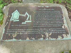
Fort Constitution (3) (1775-1783) - A Patriot Revolutionary War fort established in 1775 on Constitution Island in Putnam County, New York. The fort was captured and destroyed by the British in October 1777. The fort was partially reconstructed and garrisoned by Patriot forces after it was abandoned by the British. Became one of the anchor sites for the great chain across the Hudson from West Point. Abandoned at the end of the war in 1783.
Revolutionary War (1775-1783)Part of Fortress West Point. The original plan for Fort Constitution had bastions, a 200 foot curtain rampart (14 cannon) and five batterys with 81 cannon. Fort buildings included barracks, magazine and an octagonal blockhouse with six cannon. Only the blockhouse, a barracks and a storehouse were constructed before construction was halted in January 1776. The materials were diverted to the construction of Fort Montgomery near Bear Mountain. Fort Montgomery, Fort Clinton and Fort Constitution were all captured and destroyed by British troops in their October 1777 attack up the Hudson River. Fort Constitution was reoccupied by Patriot forces after the british left and partially rebuilt. The fort and Constitution Island became the eastern terminus of the great chain across the Hudson River from West Point. The role of the batteries on the island and Fort Constitution shifted to stopping British ships from passing West Point and the protection of the great chain and the log barrier. The construction of Fort Clinton and all the supporting batteries, redoubts and forts on the West Point side all focused on the same goal. Current StatusPart of the United States Military Academy on Constitution Island in Putnam County, New York, An active Military installation and access may be restricted.
See Also:
Sources:
Links: Visited: 11 May 2012
| ||||||


