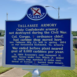
Tallassee Confederate Armory
|
HistoryColonel Gorgas, Confederate ordnance chief, removed carbine manufacture from the Richmond Arsenal to Tallassee as Union forces closed in around Richmond. In the spring of 1864, the new armory was housed in leased facilities in an 1844 Cotton mill building that was still producing war supplies. The production goal for carbines at the new facility was set at 6,000 per year but the war ended before they neared that goal. Major Taylor at the Confederate Armory reported that by early 1865, approximately 500 Tallassee Carbines had been produced. These were reportedly .58 caliber percussion muzzle-loading carbines. In March of 1865, Union Maj. General James H. Wilson advanced to raid Alabama with 13,000 troops. Concerned for the safety of the carbines in Tallassee, orders came to remove the rifles and all manufacturing equipment and ship them to Macon, Georgia. The Tallassee carbines were probably shipped via rail to Macon. Only 12 carbines are known to have survived and those are all in museums. It is possible that the Union forces had taken Macon by the time the carbines arrived there and they were destroyed by them. The dozen that have survived were probably taken by Union officers as souvenirs. Tallassee was never attacked by Union forces and the Tallassee Armory was the only Confederate Armory not destroyed during the war. The Armory was abandoned in 1865 at the end of the war. Current Status A Roadside marker is located on the bridge above the Armory site. The main mill building still stands but the interior structure is in ruins with some fire damage. The mill structures are enclosed inside a fenced compound with a locked gate.
See Also: Sources: Links:
Visited: 7 Aug 2021, 19 Apr 2016
| |||||||
