K.I. Sawyer SAGE Direction Center DC-14
|
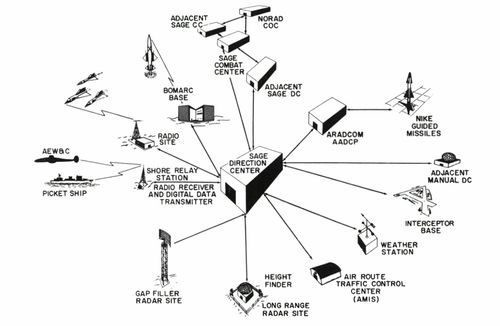
K.I. Sawyer SAGE Direction Center DC-14 (1960-1963) - A Cold War SAGE System Direction Center first established in 1960 on K.I. Sawyer Air Force Base, Marquette, Marquette County, Michigan. Named K.I. Sawyer SAGE Direction Center DC-14 after the location. Assigned a Sage ID of DC-14. Deactivated as a SAGE Direction Center in 1963. History of K.I. Sawyer SAGE Direction CenterEstablished and became operational on 15 Jun 1960 as K.I. Sawyer SAGE Direction Center DC-14 on K.I. Sawyer Air Force Base in Marquette, Michigan.  Direction center equipment included the duplex FSQ-7 computer system and associated communication equipment. The FSQ-7 computer system assembled digitized inputs from USAF Radar Sites to provide tracking and identification of all aircraft within their sector of responsibility. The digitized radar inputs came from USAF Radar Sites, airborne radar pickets, Texas Towers, Gap Filler Radar Sites and other radar sources. The total picture of aircraft in the sector was assembled and any unknown aircraft were checked out and hostile aircraft were engaged by USAF fighter aircraft, Bomarc missiles or NIKE missiles. The primary defense was against the Soviet threat of a mass nuclear bomber attack on the US. The system evolved before the advent of ICBMs and provided no missile defense against them. The computer technology was first generation vacuum tube equipment and required significant power and air conditioning. The physical plant of the direction center was enclosed in a large multi-story concrete blockhouse that housed the duplex FSQ-7 computer, communications equipment, a powerhouse, air conditioning systems and operational areas. The operational areas included radar mapping, air surveillance, identification, communications and weapons direction. The enormous cost of the radar sites, direction centers, personnel, and training caused an immediate reevaluation and almost as quickly as they were built some facilities were closed. The first mass closures began in the 1960s when many radar sites and virtually all the gap filler sites were closed. The first round of direction center closures came in 1963 when six were closed, a second round in 1966 and a third in 1969 that closed a total of 17 out of 23. The remaining six direction centers became SAGE Regional Control Centers (RCCs) still using the massive FSQ-7 vacuum tube computers. As the direction centers and radar sites closed the remaining sites were realigned into ever-increasing sectors. A new Joint Surveillance System (JSS) evolved as a partnership between the Air Force and the FAA to provide nationwide radar coverage. When completed in 1983 it consisted of only forty-six radar sites feeding into four new Region Operation Control Centers (ROCCs) with FYQ-93 computer systems. With the activation of the four U.S. ROCCs and the two Canadian ROCCs, the last seven of the SAGE direction centers were deactivated and this signaled the end of the SAGE system. Of the remaining forty-six radar sites, thirty-one had FAA-operated search radars and USAF operated height finders. Five sites just had FAA search radars and only ten sites were operated by the Military. With the deployment of forty FAA ARSR-4 3D radar sets in the 1990s, the earlier military and FAA radars were replaced. The Canadians closed their underground SAGE Direction Center and created two ROCCs (CAN-East and CAN-West) using the FYQ-93 computers in the underground facility.
The K.I. Sawyer SAGE Direction Center DC-14 was deactivated on 15 Dec 1963 in the first round of SAGE Direction Center closures.
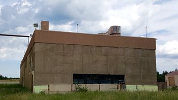
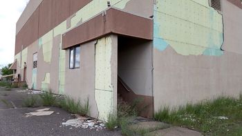
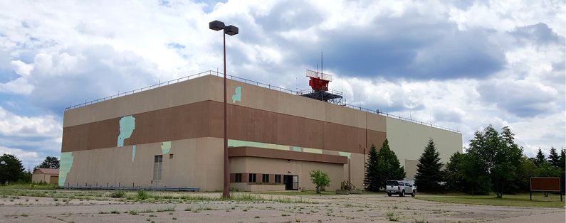
Current StatusSage Direction Center blockhouse now in private hands and repurposed on the former K.I. Sawyer Air Force Base in Marquette, Marquette County, Michigan. The base was closed in 1996. Exterior covering of the blockhouse is deteriorating and separating from the concrete walls.
See Also: Sources:
Links: Visited: 5 Jul 2016 |


