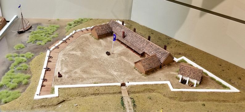
Fort Lyttleton (2)
|
Fort Lyttleton (2) (1758-1782, 1807-1825) - A French & Indian War Fort established in 1758 but not completed until 1764. Located on Spanish Point near Port Royal, Beaufort County, South Carolina. Named Fort Lyttleton after William Henry Lyttleton, Royal Governor of South Carolina (1756-1760). Abandoned in 1782. Rebuilt starting in 1807 as a Second System fort, renamed Fort Marion about 1814, finally abandoned in 1825. An alternate spelling is Fort Littelton. Also known as Beaufort Battery.
French & Indian War (1754-1763)Established in 1758 as a French & Indian War fort but not completed until 1764 as the war was ending. The fort was built as a 400' by 375' triangle with the base side along the Port Royal River and the point faced toward the land side, forming a protective bastion. This was a tabby built fort complete with barracks and other structures. A caretaker garrison occupied the fort during the 1760s. Revolutionary War (1775–1783)South Carolina forces occupied the fort at the start of the Revolutionary War and it was used initially to just store gunpowder. With the fall of Savannah in 1778 British troops moved to occupy South Carolina. The battle of Port Royal Island on 3 Feb 1779 resulted in the British retreating but not before the Patriots under Captain John Francis DeTreville (SC 4th Regiment) had already spiked the cannons and blown up Fort Lyttleton. The fort did not see action during the remainder of the war. After the war, the fort was renamed Beaufort Battery by the Americans War of 1812 (1812-1814)In 1807 Fort Lyttleton was refurbished with palmetto log construction as the troubles with Great Britain began to look like they might result in war. The Corps of Engineers recommended the erection of works at the site of Fort Lyttleton using tabby construction later estimated to cost $16,727.77. The Secretary of War was dismayed at this and ordered construction halted. By 1811 only 4 foot high foundations were in place. In 1812 work was resumed under Captain Prentiss Willard, (Cullum 19), Corps of Engineers and early in 1813 troops were assigned. By 1814 the fort is referred to as Fort Marion and is considered as a part of the Second System fortifications. The fort itself was a semicircular bastion constructed of tabby and earth mounting seven guns on a platform. The fort saw no action during the war but state and federal units were stationed there. Abandoned about 1825. Current StatusArcheological site remains only. A 1978 excavation revealed the front wall of the fort which was 7' wide by 10' deep. Excavations also revealed a semicircular wall 175' long and 8' wide with 6 to 8 gun ports, tabby built (oyster shell and lime concrete) that mirrors the Fort Marion period construction. The site is located on private property and was backfilled after the architectural excavations. Site number 38BU149.
See Also: Sources:
Links:
Visited: Not located
| ||||||
