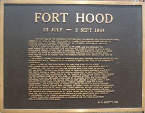
Fort Hood (2)
|
Fort Hood (2) (1863-1864) - A Confederate defensive position established in 1863 in the defense of Atlanta during the U.S. Civil War. Named after Confederate General John B. Hood (Cullum 1622). Abandoned in 1864.
HistoryFort Hood was the northwest salient of the Confederate inner defensive ring around the City of Atlanta built in summer and fall of 1863 during the U.S. Civil War. Construction consisted of series of 17 massive earthen redoubts all connected by rifle pits that surrounded the city. Construction was designed and supervised by Confederate Capt. Lemuel P. Grant and was completed by 12 Apr 1864. Abandoned in 1864 after the fall of Atlanta to Union forces. Current StatusA marker only, now located on the street side wall at 793 Marietta Street NW, Loomis Security Company building.
Sources: Links: Visited: 9 Jul 2010
|

