Fort Grenadier
|
Fort Grenadier (1749-Unknown) - Fort Grenadier was a British Colonial Coastal Fort in Halifax, Nova Scotia, Canada. Deactivation date unknown.
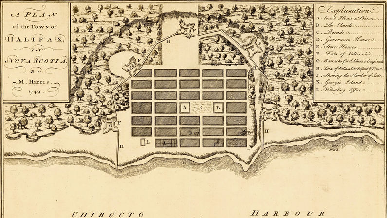
History of Fort GrenadierPart of the Harbor Defense of Halifax. The town of Halifax was established on 21 Jun 1749 by Governor Edward Cornwallis and about 2,500 settlers. With Cornwallis were only two companies of soldiers. By July he had added two full regiments of troops from Fortress of Louisbourg to guard against attacks by hostile Indians and the Acadian French. Cornwallis had his principal engineer, John Brewse, devise a plan for a land side defense of the town and harbor. Brewse's plan was to create a horseshoe type defense around the town with five forts connected by a palisade on the land side while the open part of the horseshoe along the shore could be protected by gun batteries The forts themselves were square with protruding bastions at each corner. The outer dimensions were 193' from bastion tip to bastion tip, while the inner square dimensions were 125' on a side with curtains of 75'. Trees were cleared back some 30' to provide a field of fire. The fort walls were double set 10' high logs, 6" around. The double set logs were set upon one another so that the gaps were all covered and then loopholes were cut for guns. Inside each fort were barracks for two companies of soldiers, about 100 men. Fort Grenadier was one of five forts built under this plan. It was located at the north end of town. The palisade ran west from the fort to Fort Luttrell and east to the shoreline. The palisade was designed with intermediate angles that allowed the defenders to direct enfilading fire along the walls without hitting the occupants of the next fort. Deactivation date unknown but the barracks were still in use in 1784. Current StatusNo remains. No period guns or mounts in place.
See Also: Sources:
Links: Visited: No
| ||||||
