Colville Air Force Station
|
Colville Air Force Station (1951-1961) - A Cold War Air Force Radar Station first established in 1951 near Colville, Stevens County, Washington. Named Colville Air Force Station after the location. Initially assigned a site ID of LP-60 and using surplus Lashup System equipment. A Permanent ID of P-60 was assigned when permanent system equipment was installed in 1952. The site was integrated into the SAGE System in 1960 and then abandoned in 1961.
History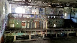 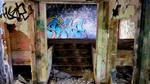 Operation began at the Colville radar site in March 1951 under a site ID of LP-60 using Lashup System surplus equipment. The site initially used a TPS-1B radar and in November 1951 a TPS-1C was installed. The permanent site, with a site ID of P-60, became operational in February 1952 and was manned by the 760th AC&W Squadron. Initially, The station had a Ground-Control Intercept (GCI) and an Early Warning (EW) mission. The early warning mission involved tracking and identifying all aircraft entering their airspace while the GCI mission involved guiding Air Force interceptors to any identified enemy aircraft. Controllers at the station vectored fighter aircraft at the correct course and speed to intercept enemy aircraft using voice commands via ground-to-air radio. Initial P-60 equipment included the FPS-3 search radar and the FPS-5 height-finder radar.
SAGE System Transition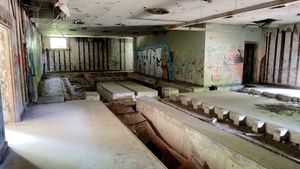 The transition of the manual GCI system to the automated SAGE system began with the installation of the FST-2 coordinate data transmitter and search radar upgrades. The FST-2 equipment digitized the radar returns and transmitted the digital returns to the SAGE direction center. Under the SAGE System, interceptor aircraft were directed to their targets by the direction center computers and controllers, greatly reducing the need for local controllers and equipment at every radar station. The FST-2 was a very large digital system using vacuum tube technology. Over 6900 vacuum tubes were used in each FST-2 requiring 21 air-conditioned cabinets, 40 tons of air conditioning, 43.5 kva of prime power, and usually a large new addition to the operations building. The FST-2B modification added two more cabinets but with newer solid-state (transistor) technology to process coded responses from aircraft transponders. According to newspaper accounts, the FST-2 installation at Colville AFS began in September of 1959. On 1 Sep 1960, the 760th AC&W Squadron was redesigned the 760th Radar Squadron (SAGE) to reflect integration into the SAGE System. SAGE System OperationThe site began operation as a SAGE site in 1960 initially feeding the Larson SAGE Direction Center DC-15. In preparation for SAGE implementation the search radar was upgraded from the FPS-3 search radar to an FPS-20 search radar. In 1956 the FPS-5 height-finder radar was replaced with one FPS-6 height-finder and a second FPS-6A was added later. The 760th Radar Squadron and Colville Air Force Station were discontinued 1 Jun 1961.
Gap Filler RadarsColville AFS was responsible for the maintenance of three remote unattended gap-filler radar sites. The unattended gap filler sites were placed in locations where the main search radar lacked coverage. These sites were equipped with short range FPS-14 or FPS-18 search radars and FST-1 Coordinate Data transmitters that sent digitized radar target data to a SAGE direction center and to the main radar site. Both the radar set and the FST-1 were dual channel to increase site up time. Maintenance teams were dispatched for regularly scheduled maintenance or when fault indicators on the FSW-1 remote monitoring equipment suggested the site had problems. The FSW-1 also allowed remote operation of specific functions such as channel changes for the radar and for the FST-1, it also allowed remote operation of the diesel generators at the gap filler site. The Colville AFS gap-filler radars were located at Iona, WA; Curlew, WA, and Okanogon, WA. Two other gap-filler sites were planned, one at Northport, WA and one at Mazama, WA. These two sites were at least partially constructed but they did not become operational.
Physical PlantThe physical plant of the site was divided into an upper main site, a lower cantonment area, a separate lower housing area, and two radio sites. The upper main site housed the operations buildings, the radar towers, and the backup generators. The cantonment area housed the enlisted barracks, the bachelor officer's quarters, the orderly room, the dining hall, the motor pool, and other support buildings. Apart from the cantonment site was a small nine-unit housing area for critical married personnel. A separate radio site housed the radio equipment for directing aircraft intercepts. Like most early radar stations, Colville originally had a radio transmitter site and a separate radio receiver site used by local controllers for voice direction of fighter interceptors to their targets. With the SAGE System, the SAGE Direction centers had the primary task of directing intercepts and the local radio sites were reconfigured, usually into a single site that was known as the Ground to Air Transmitter Receiver (GATR) site. The GATR site communicated with the interceptors from either the local site or the SAGE direction center via voice commands and/or a digital data link.
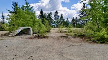
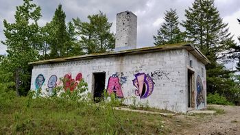
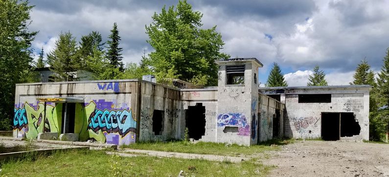
Current StatusAbandoned in Colville, Stevens County, Washington. Very little remains of the housing area and the cantonment area. Only slight bits of foundations can be seen but both sites have exposed sewer manhole covers to verify their locations. The upper main site is remarkably intact although damaged and covered with graffiti. The damage to the operations building, mainly holes in the walls, actually allows enough light inside to allow photography and inspection. The structure of the operations room dias remains, is exposed and can be examined. The SAGE Annex is empty but the structure and the cable throughs are exposed so the layout is easy to confirm. The upper site gate shack is collapsed with only the flat roof visible. The supply building is gone with only the foundation remaining. The radar towers are gone with only some foundational elements remaining. The power building and the radio building remain standing but are empty. The road to the site is passable in a normal passenger car. The site was visited on 5 Jun 2017.
See Also: Sources:
Fortification ID:
Visited: 5 Jun 2017
| |||||||||||||||||||||||||||||||||||||||||||||||||||||||||||||||||||||||||||||||||||||||||||||||||||||||||||||
