Brookfield Air Force Station
|
Brookfield Air Force Station (1951-1959) - A Cold War U.S. Air Force Radar Station established during the Korean War. Located near Brookfield Center, Trumbull County, Ohio. Initially assigned a Permanent ID of P-62. Activation allowed the closure of Lashup site L-18 at Ravenna. Closed in 1959 when the squadron relocated to Oakdale Air Force Station, Ohio. HistoryEstablished in 1951 and became operational in April 1952 as Brookfield Air Force Station manned by the 662nd Aircraft Control & Warning (AC&W) Squadron. Initial equipment included the FPS-3 search radar and one FPS-5 height-finder radars. The FPS-5 height-finder radar was replaced with a FPS-4 and then with a FPS-6. The site was programmed to receive a SAGE System Annex in 1956-1957 but an attempt was made to cancel it in 1956 when it became known that the site would be moving to Oakdale Air Force Station in 1959. ClosureBrookfield AFS was deactivated on 1 Nov 1959 and the 662nd AC&W Squadron relocated to Oakdale Air Force Station, Ohio. The GATR Radio site remained open into the 1970s maintain by an operating location of the 662nd as GATR Site R-12. Gap FillersBrookfield AFS was responsible for the maintenance of two remote unattended gap-filler radar sites. The unattended gap filler sites were placed in locations where the main search radar lacked coverage. These sites were equipped with short range FPS-14 or FPS-18 search radars and FST-1 Coordinate Data transmitters that sent digitized radar target data to a SAGE direction center and to the main radar site. Both the radar set and the FST-1 were dual channel to increase site up time. Maintenance teams were dispatched for regularly scheduled maintenance or when fault indicators on the FSW-1 remote monitoring equipment suggested the site had problems. The FSW-1 also allowed remote operation of specific functions such as channel changes for the radar and for the FST-1, it also allowed remote operation of the diesel generators at the gap filler site. The Brookfield AFS gap-filler radars were located at Thompson OH and Lewisville OH.
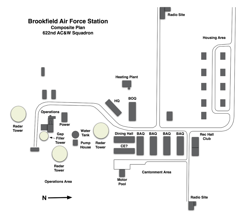
Physical PlantThe physical plant of the site was divided into the main site, a cantonment area, a housing area and two radio sites. The main site housed the operations buildings, the radar towers, and the backup generators. The cantonment area housed the enlisted barracks, the bachelor officer's quarters, the orderly room, the dining hall, the motor pool and other support buildings. Just northwest of the cantonment site was a small 9 unit housing area for married personnel. 
Current StatusMany buildings remain but in deteriorated condition and vandalized. The operations building remains. Four of the nine housing units remain, the others replaced by a water tower. Some remains of radar towers and radio sites.
See Also: Sources:
Links:
Visited: No
|