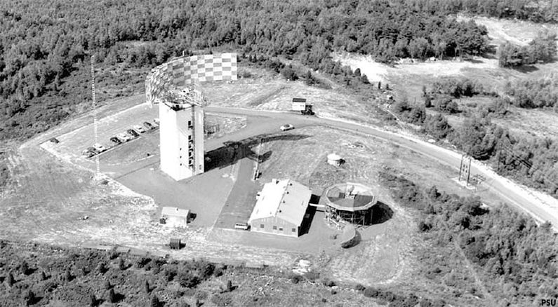
Boston Hill Mitre Radar Test Site
|
Boston Hill Mitre Radar Test Site (1959-after 1966) - A Cold War Experimental Radar Station established by Lincoln Laboratories and later transferred to MITRE Corporation. The site was located on Boston Hill near North Andover, Essex County, Massachusetts. Closed sometime after 1966.
HistoryEstablished in 1958 and became operational in 1959 as a Lincoln Laboratories replacement for the West Bath MITRE Test Radar Site which had been incorporated into the Experimental SAGE Subsector and was no longer avaliable for other research projects. The antenna and tower designs were started in September of 1956. A site on top of Boston Hill in North Andover, MA, was leased in February 1957 and construction of the seven-story radar tower was begun. The radar was first powered up in August 1958. CCM Radar Mark IThe experimental radar set itself was designated as Counter Counter Measure (CCM) Radar Mark I and borrowed from the work done on the West Bath FPS-31 but offered significant advances of its own in the development of techniques to combat active electronic jamming and passive counter-measures. This was a UHF Band radar operating between 400 Mhz and 450 MHz (mostly around 440 MHz) with a peak power of 8 MW and an average power of 28 KW. Instead of a magnetron, the transmitter used a 10' long Varian 812 (later an 812B) Klystron tube. The antenna reflector was 120' long and 30' high, rotating on a single 13.5' ball bearing. The rotating load on the bearing was 55 tons (what could go wrong with that?). The whole radar set was housed in a 7 story concrete building. The CCM Radar Mark I set the basic parameters for two Air Force Frequency Diversity (FD) radars that followed, the FPS-35 and the FPS-24, each with 12 installations, all using the same single bearing design with a tall tower to house the equipment and the antenna. FST-2 CDTA FST-2 Coordinate Data Transmitters (CDT) was installed to provide digitized fine-grain radar data. The FST-2 was located in a low peaked roof building not far from the radar tower. There is some indication that the FST-2 was maintained by Air Force Personnel. The site began operation as an experimental radar site in 1959. The MITRE Corporation took over management of the site from Lincoln Laboratories on 1 Apr 1960. Period photographs from 1966 show an apparently still active radar site with the antenna still intact. ClosureThe Boston Hill Mitre Radar Test Site was deactivated sometime after 1966.
Current StatusSome site structures still exist including the original CCM Radar Mark I concrete tower and the building that housed the FST-2 Coordinate Data Transmitter.
See Also: Sources:
Links:
Visited:
| ||||||||||||||||
