Barrack at Blairfindie
Barrack at Blairfindie (1814-1836) - A British Colonial cavalry barrack established in 1814 in present day St-Jean-sur-Richelieu, Quebec, Canada. The barrack was abandoned in 1820 and sold in 1836. It was also named Halfway House, like the camp on the same site.

Barrack at Blairfindie, The barrack

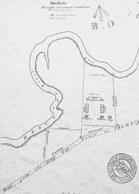
A camp was established at this strategic spot on the rented land of Pierre Tremblay on the shore of the small Lacadie River in the beginning of the war of 1812 to protect the Montreal approaches. In July 1812, several companies of British Regiments gathered there; for example, in August, 800 regular British soldiers (49th and 100th) occupied the camp at Halfway House; in October, the camp was occupied by 163 men and officers of the First Battalion of Canadian Militia. Troops gathered at Halfway House to be sent as reinforcement at Chateauguay River or at Lacolle River, two main routes of invasion to the earth of Canada. It was at the strategic corner halfway between Laprairie (barrack) and St Jean (fort and barrack), and between Chambly (fort and barrack) and Laprairie on the main roads, the Line.
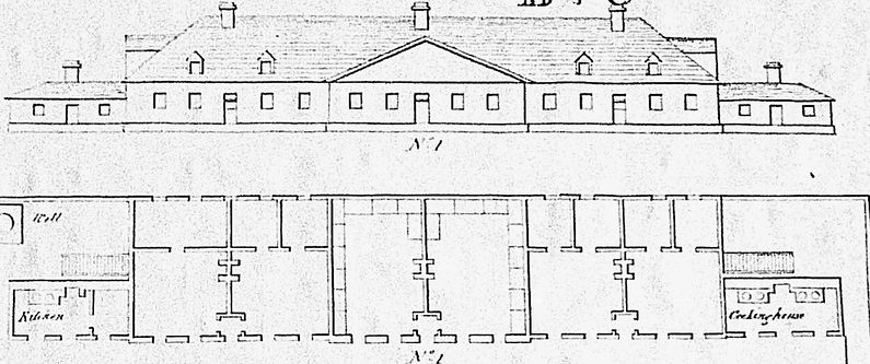
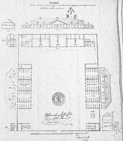
In November 1813, Major Parker and one troop of the 19th Light Dragoons (60 men), newly arrived in Canada, occupied the Barrack at Blairfindie (2 at Laprairie and one at Chambly) where 28 carpenters, 6 masons, one smith and 10 labourers worked. The 18 acres of land were purchased by the government in February 1814. Officers Quarters, Barrack for 80 men, 2 stables for 98 horses, Guard house and Sergeant Major’s Quarter with a palisade were built of wood, the Barrack at Blairfindie, for the name of the village (now Lacadie), were completed in June. It was like a small square wood fort because a palisade closed the spaces between the buildings, the forge was outside. In January 1815, after the end of the war, the Barrack was still occupied by Major Robert Lisle, 4 officers and 80 men of the 19th light Dragoons. In October 1815, the Barrack needed repairs, and some painting, what is done by October 1817. The Barrack was still garrisoned in 1819 by 85 cavalrymen. In 1820, the barrack was abandoned to a guardian, Francis Morrow. In 1825, a part of the barrack was rented to sergeant Power. A guardian was maintained until 1836, when the barrack lot and buildings were sold for 432 pounds.
Barrack at Blairfindie, History

Since the first days of the war of 1812, British occupied the Halfway House camp to dispatch troops where it was needed on the border. Since the last war (1775-1783) many roads were built between New York State and Montreal, so it became impossible to block every way to Montreal with permanent fortifications, only a fort at l’Isle aux Noix remained to stop the navigation from Lake Champlain to St Jean, so the new British strategy was to have troops ready to go quickly to the point of the border attacked by American troops where they had outposts. This situation happened few times in Lacolle River area, close to the Richelieu River way and at the Chateauguay River, invasions were repulsed. The Barrack at Blairfindie served also in the preparations of the unsuccessful British invasion of Plattsburgh NY and the Battle of Lake Champlain in September 1814. After the war, when the divergence eased between USA and England, the Barrack, like other military posts, was abandoned and sold. There was archeological research in December 1980 by Ministère des Affaires Culturelles du Québec. The archeological site is important because the barrack was occupied during a short known period (1814-1819) by only one group (19th Light Dragoons) on an undisturbed site.
Current Status
The site is a private property and there is no sign. Nothing remained of the barrack but foundations of most of the buildings (barrack, one stable, guardhouse). Archeological research revealed latrines and some other buildings artifacts.
|
{"selectable":false,"height":"-500","width":"-500"} |
Location: Saint-Jean-sur-Richelieu, Quebec, Canada. Maps & Images Lat: 45.38260 Long: -73.36984 |
|}