Baleville WWII Radar Site
|
Baleville WWII Radar Site (1943-1944) - A World War II U.S. Army Signal Corps Radar Site established in 1943. Used to provide early warning and direction of intercepts of enemy aircraft approaching the Washington Coast. Located in the unincorporated community of Baleville near Raymond in Pacific County, Washington. Deactivated in 1944. Also known as Station L-63.
HistoryThis radar site was established during World War II early in 1943 as a part of a chain of 65 radar stations along the West Coast of the United States and Canada. These secret radar sites were built to provide early warning and interception of approaching enemy aircraft and ships but also served to assist friendly aircraft that were lost or had in-flight emergencies. This radar network was in addition to a network of search and fire control radars established at each of the West Coast harbor defenses. This chain of West Coast radar stations was established in response to the June 1942 Japanese invasion and capture of the U.S. Aleutian Islands of Attu and Kiska. The islands were both recaptured by U.S. forces and declared secured by 24 Aug 1943. The radar chain was constructed in late 1942 and early 1943 while the Japanese still had control of the islands and had conducted air raids on the U.S. bases at Dutch Harbor. The threat of further air attacks on the West Coast appeared real as did a possible Japanese invasion of the Pacific Northwest. 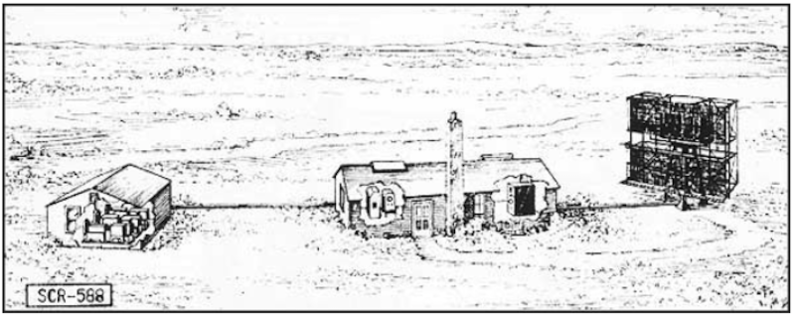 Two types of Air Warning Service (AWS) radar stations were built, long-range search radars (200~ mile range) and short-range Ground Control Intercept (GCI) radars (50~ mile range). The search radars would pick up and track possible enemy aircraft while the GCI radars would guide U.S. interceptor aircraft to these targets. The long-range search radar sites typically used the SCR-270 series radars while the GCI sites typically used the SCR-588 series radars. The Baleville radar site was sited as a GCI site with a SCR-588 radar set. The radar site was operational from sometime in June 1943 until 1 Jul 1944. Manning over this period of time was between 45 to 50 men operating as a detachment of the 652nd Signal Aircraft Warning (SAW) Company with a headquarters at Paine Field, Washington (note: the detachment numbers and unit designation changed several times while the site was active). During this short time of time the following personnel oversaw the operation of the site:
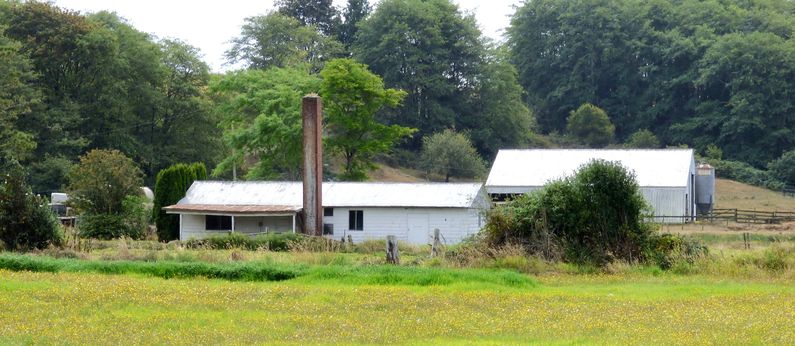
Physical PlantThis installation was a split site with the Radar Operations area separate from the Cantonment area. The Cantonment area was located on a hill 600 yards from the operations site by road and about half that by the line of sight. 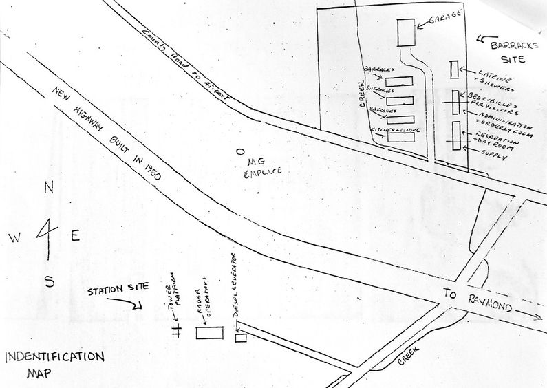 The operations site was built at the base of the hill facing westward over the flat delta at the mouth of the Willapa River where it flows into Willapa Bay and out into the Pacific Ocean. Structures on the Operations Site included the SCR-588 antenna on a concrete base, the operations building housing the radar set and operations area, a generator building, and a guard shack. All of this was on a small 1.33-acre site surrounded by a security fence. The Cantonment site was located along the road that connected Raymond to Tokville about four miles west of Raymond, Washington. Construction was almost complete when the troops arrived in May 1943 but the troops helped to complete the finish work including installing windows. There were seven structures in the cantonment, three barracks, a mess hall, a common latrine/shower building, an administration/orderly room, and a dayroom/supply building. A garage building was later built at the end of the camp road. The cantonment area was on an 8.06-acre site with no guard shack. Note: The cantonment area is locally known as Camp Baleville and local references can be found under this name. Protection against enemy attack was limited to three 50 caliber machine gun positions placed around the area. The closest Post Office was in Raymond and the unit Mailing Address was: ClosureSpecial Order #15, 17 Jun 1944, detailed the plan for deactivation and evacuation. The men not essential to the disassembly and packing of the radar and other gear would leave on 3 Jul 1944 by convoy from the five local detachments to Aberdeen for assembly and then to Paine Field that same day by truck. The remainder would follow when the gear was ready for shipment. The buildings were left intact but all accountable property was removed. The detachments and the number of men initially affected by the order were listed as:
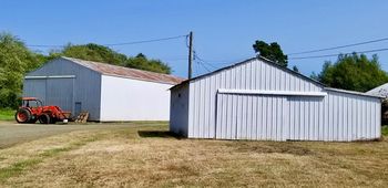
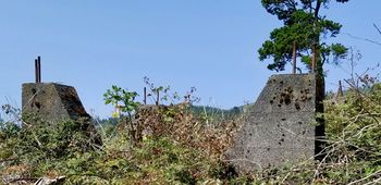
Current Status Cantonment Site - Now Pacific County property. The Cantonment area was sold into private ownership and repurposed with some of the buildings becoming private housing or storage areas. By 2015 the former Cantonment area had fallen into disrepair and was occupied by squatters. Pacific County took over the property for back taxes on 12 Dec 2014 and had all of the remaining structures razed. All that remains of the Cantonment area now is the dirt road and a single power pole. Operations Site - Now private property. After the war, the separate Operations area was returned to private ownership and combined with an adjoining farm. Three or four buildings initially remained, the operations building, a powerhouse, perhaps a radio building, and a gate shack. Only the operations building and the power building still remain (a/o August 2018). The current owner converted the operations building into a residence and lived there until the 1970s when he built his current residence. The building was then used as rental property for several years and is currently used for storage. The Operations building retains its characteristic tall central chimney, heating system, entryway, and duct system but the interior is heavily modified for household use and commercial windows have been installed. The powerhouse building is used as a garage/workshop but the outlines of the generator pads and the cable races can be seen. Both buildings are in good shape considering their age and both now have metal roofs. The concrete antenna supports are fully intact and would probably require only that the bolts be cleaned of rust to be placed back in service. The antenna supports are overgrown with blackberry vines but are otherwise in very good shape.
See Also: Sources:
Links: Fortification ID:
Visited: 16 Aug 2018
| |||||||
