Alaska Manual System Radar Sites
-->
The need for an air defense system in Alaska became clear in the late 1940s and early 1950s as the Soviet Union developed atomic weapons and long-range aircraft to deliver them to U.S. and Canadian targets. The proximity of Alaska to the Soviet Union made it very vulnerable to air and land attack. Construction of aircraft control and warning radar sites commenced about 1950 and the first sites were operational in 1951.
-
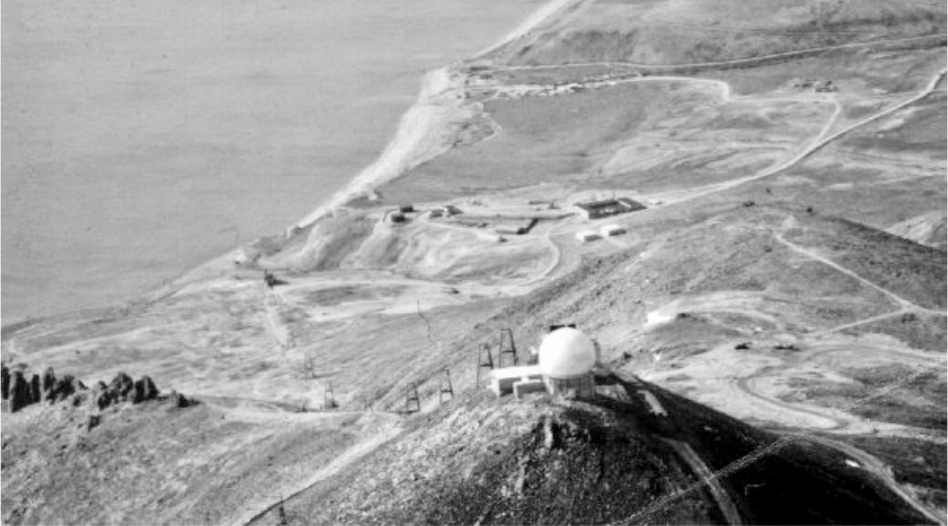 Tin City Air Force Station Upper Site, Lower Site in Background. Note the large composite building on the lower site and the tramway between the sites.

The build-out of radar sites continued throughout the 1950s under very adverse conditions. Just building the sites was a herculean task because of the remote locations and adverse weather conditions. Once built, the sites had to be manned and supplied. At many of the sites, the only means of supply was from the air on short dangerous dirt airstrips. Personnel were assigned to the sites on a one-year remote tour which meant there was a constant turnover of personnel and little continuity. Fire was a constant danger and several sites experienced multiple fires that destroyed mess halls, quarters, and other facilities.
Initially, communication between the remote sites and with higher headquarters was via military radio equipment. This quickly proved inadequate and at some sites, the radio exchanges were so garbled that they could not be relied on. Construction of the Alaska White Alice troposcatter communications network in the late 1950s solved most of the communications problems. The White Alice system remained in operation until the late 1970s when it was replaced by direct satellite links.

While the manual radar sites in the lower 48 states were being automated into the SAGE System in the late 1950s and early 1960s, Alaska was not to be a part of the SAGE System. The Alaska radar sites remained in manual mode until 1965 when a kludged together system known as the FYQ-9, semi-automated the radar track following functions. The FYQ-9 still required an operator to initiate radar tracks at the radar site.
The further automation of the manual system required several technology events and resulted in the deactivation of all the AC&W Squadrons, the replacement of all the radar sets at all the remaining radar sites, and contractor maintenance of all the remaining radar sites. The technology events that precipitated these major changes included Common Digitizers and satellite terminals at the radar sites and the activation of the FYQ-93 at the new Elmendorf JSS ROCC in 1983.
| Site | Man ID | JSS ID | ID 3 | Func | Unit | Command | From | To | GPS | Notes |
|---|---|---|---|---|---|---|---|---|---|---|
| Fire Island | F-01 | JDC | 626th | 10th AD | 1951 | 1969 | 61.14111, -150.21806 |
|||
| Murphy Dome | F-02 | A-02 | JDC | 744th | 11th AD | 1951 | 1983 | 64.951944, -148.35681 |
||
| King Salmon | F-03 | A-07 | C-01 | ADCC | 705th | 10th AD | 1951 | 1983 | 58.692500, -156.670278 |
|
| Tin City | F-04 | A-11 | ?? | 710th | 11th AD | 1953 | 1983 | 65.57579, -168.01207 |
||
| Cape Newenham | F-05 | A-09 | EW | 794th | 10th AD | 1954 | 1983 | 58.62659, -162.07595 |
||
| Cape Romanzof | F-06 | A-10 | EW | 795th | 10th AD | 1953 | 1983 | 61.789722, -165.961944 |
||
| Cape Lisburne | F-07 | A-13 | EW | 711th | 11th AD | 1953 | 1983 | 68.8705, -166.15085 |
||
| Campion | F-08 | A-04 | ADCC | 743nd | 11th AD | 1952 | 1983 | 64.70583, -156.72806 |
||
| Northeast Cape | F-09 | ?? | 712th | 10th AD | 1953 | 1969 | 63.29116, -168.96887 |
|||
| Tatalina | F-10 | A-05 | C-02 | GCI | 717th | 10th AD | 1952 | 1983 | 62.92917, -156.01417 |
|
| Fort Yukon | F-14 | A-01 | GCI | 709th | 11th AD | 1958 | 1983 | 66.56083, -145.20944 |
||
| Sparrevohn | F-15 | A-06 | GCI | 719th | 10th AD | 1954 | 1983 | 61.11915, -155.59609 |
||
| Indian Mountain | F-16 | A-03 | GCI | 708th | 11th AD | 1953 | 1983 | 66.06873, -153.68624 |
||
| Unalakleet | F-20 | GCI | 718th | 10th AD | 1958 | 1969 | 63.91755, -160.75087 |
|||
| Bethel | F-21 | C-03 | GCI | 713th | 10th AD | 1958 | 1963 | 60.785500, -161.882677 |
||
| Middleton Island | F-22 | ?? | 720th | 10th AD | 1958 | 1963 | 59.43611, -146.33056 |
|||
| Kotzebue | F-24 | A-12 | GCI | 748th | 11th AD | 1958 | 1983 | 66.84333, -162.59556 |
||
| Ohlson Mountain | F-25 | GCI | 937th | 10th AD | 1958 | 1963 | 59.71389, -151.53472 |
|||
| Cold Bay | F-26 | A-08 | ?? | 714th | 10th AD | 1959 | 1983 | 55.24513, -162.76964 |
Context
Related:
Bethel Air Force Station, Campion Air Force Station, Cape Lisburne Air Force Station, Cape Newenham Air Force Station, Cape Romanzof Air Force Station, Cold Bay Air Force Station, Defense Installations Portal, Elmendorf JSS ROCC, FYQ-9, FYQ-93, Fire Island Air Force Station, Fort Yukon Air Force Station, Indian Mountain Air Force Station, King Salmon Air Force Station, Kotzebue Air Force Station, Middleton Island Air Force Station, Murphy Dome Air Force Station, Northeast Cape Air Force Station, Ohlson Mountain Air Force Station, Sparrevohn Air Force Station, Tatalina Air Force Station, Tin City Air Force Station, Unalakleet Air Force Station, Adak White Alice Communications Site, Aniak White Alice Communications Site, Anvil Mountain White Alice Communications Site, Bear Creek White Alice Communications Site, Big Mountain White Alice Communications Site, Pedro Dome White Alice Communications Site,