Fort Frederica: Difference between revisions
John Stanton (talk | contribs) No edit summary |
John Stanton (talk | contribs) No edit summary |
||
| Line 9: | Line 9: | ||
[[Image:Fort Frederica - 07.jpg|thumb|left|200px|Fort Frederica Plan Sign]] | [[Image:Fort Frederica - 07.jpg|thumb|left|200px|Fort Frederica Plan Sign]] | ||
The town was laid out in a rectangular plat within a fortified polygon that surrounded the whole town. The outer fortification included palisaded earthworks and a surrounding moat. A central fortification within the outer fortification stood on the river bank and included palisaded earthworks enclosing a sallyport, the kings magazine, two storehouses and gun batteries. On the north end of the outer fortification stood stone barracks and the parade. | The town was laid out in a rectangular plat within a fortified polygon that surrounded the whole town. The outer fortification included palisaded earthworks and a surrounding moat. A central fortification within the outer fortification stood on the river bank and included palisaded earthworks enclosing a sallyport, the kings magazine, two storehouses and gun batteries. On the north end of the outer fortification stood stone barracks and the parade. | ||
{{Clr}} | |||
[[Image:Fort Frederica Military Road.jpg|thumb|left|200px|Fort Frederica Military Road]] | [[Image:Fort Frederica Military Road.jpg|thumb|left|200px|Fort Frederica Military Road]] | ||
On 25 Sep 1738 the military garrison and the townspeople started a six mile road to British [[Fort Saint Simons]] on the tip of Saint Simons Island. The military road was completed in three days and greatly strengthened the island's defenses. This road played a role in defeating Spanish invaders on 7 Jul 1742 at Gully Hole Creek and Bloody Marsh. | On 25 Sep 1738 the military garrison and the townspeople started a six mile road to British [[Fort Saint Simons]] on the tip of Saint Simons Island. The military road was completed in three days and greatly strengthened the island's defenses. This road played a role in defeating Spanish invaders on 7 Jul 1742 at Gully Hole Creek and Bloody Marsh. | ||
{{Clr}} | |||
== Current Status == | == Current Status == | ||
Period guns and mounts in place. | Period guns and mounts in place. At the time these pictures were taken the cannons were off being refurbished. | ||
{| | {| | ||
| | | | ||
Revision as of 07:49, 26 February 2010
Fort Frederica (1736-1763) - First established in 1736 by Gen. James Oglethorpe. Abandoned in 1763.


Fort Frederica History
Established as a fortified community of British settlers in 1736. One hundred sixteen settlers arrived in March and April of 1736.

The town was laid out in a rectangular plat within a fortified polygon that surrounded the whole town. The outer fortification included palisaded earthworks and a surrounding moat. A central fortification within the outer fortification stood on the river bank and included palisaded earthworks enclosing a sallyport, the kings magazine, two storehouses and gun batteries. On the north end of the outer fortification stood stone barracks and the parade.

On 25 Sep 1738 the military garrison and the townspeople started a six mile road to British Fort Saint Simons on the tip of Saint Simons Island. The military road was completed in three days and greatly strengthened the island's defenses. This road played a role in defeating Spanish invaders on 7 Jul 1742 at Gully Hole Creek and Bloody Marsh.
Current Status
Period guns and mounts in place. At the time these pictures were taken the cannons were off being refurbished.
|
{"selectable":false,"width":"500"} |
Location: Fort Frederica National Monument, Glyn County, Georgia. Maps & Images Lat: 31.223307 Long: -81.393440 |
Sources:
- Roberts, Robert B., Encyclopedia of Historic Forts: The Military, Pioneer, and Trading Posts of the United States, Macmillan, New York, 1988, 10th printing, ISBN 0-02-926880-X, page 221-222
Links:
Visited: 20 Jan 2010
Fort Frederica Picture Gallery
|
Click on the picture to see a larger version. Contribute additional pictures - the more the better! |
-
 Fort Frederica Entrance Sign
 -
 Fort Frederica Visitor Center Sign
 -
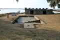
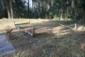
 Fort Frederica House Foundation
 -
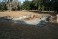
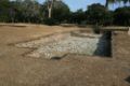
 Fort Frederica Site
 -
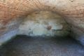 Fort Frederica Kings Magazine Interior
 -
 Fort Frederica Storehouse Foundation
 -
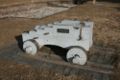 Fort Frederica 32 Pounder Carriage
 -
 Fort Frederica Earthworks
 -
 Fort Frederica Bastion Outline
 -
 Fort Frederica Cemetery Burial Vault


