Fort Harrod: Difference between revisions
John Stanton (talk | contribs) No edit summary |
John Stanton (talk | contribs) No edit summary |
||
| Line 1: | Line 1: | ||
{{SocialNetworks}} | {{SocialNetworks}} | ||
'''{{PAGENAME}} (1777-?)''' - First established as a camp by [[James Harrod]] 16 Jun 1774. Fort Harrod was built in 1777 on Old Fort Hill and named after [[James Harrod]]. | |||
{{Clr}} | {{Clr}} | ||
[[Image:FortHarrod KY - 15.jpg|400px|thumb|left|Fort Harrod front gate]] | [[Image:FortHarrod KY - 15.jpg|400px|thumb|left|Fort Harrod front gate]] | ||
[[Image:FortHarrod KY - 4.jpg|thumb|400px|right|Fort Harrod bastion]] | [[Image:FortHarrod KY - 4.jpg|thumb|400px|right|Fort Harrod bastion]] | ||
{{Clr}} | {{Clr}} | ||
=={{PAGENAME}} History== | =={{PAGENAME}} History== | ||
The original camp on Landing Run Creek quickly became Harrodstown, the first pioneer settlement in Kentucky. The original site flooded and the settlers constructed a new and larger fort on Old Fort Hill. The community of Harrodstown grew into present day Harrodsburg, the county seat of Mercer County. | The original camp on Landing Run Creek quickly became Harrodstown, the first pioneer settlement in Kentucky. The original site flooded and the settlers constructed a new and larger fort on Old Fort Hill. The community of Harrodstown grew into present day Harrodsburg, the county seat of Mercer County. | ||
| Line 18: | Line 11: | ||
{| | {| | ||
| | | | ||
<googlemap lat="37.761928" lon="-84.84694" type="map" zoom="16" width="500" scale="yes" overview="yes" controls="large" icons="http://www.fortwiki.com/mapicons/icon{label}.png"> | <googlemap version="0.9" lat="37.761928" lon="-84.84694" type="map" zoom="16" width="500" scale="yes" overview="yes" controls="large" icons="http://www.fortwiki.com/mapicons/icon{label}.png"> | ||
(F) 37.761928, -84.84694 | (F) 37.761928, -84.84694 | ||
{{PAGENAME}}<br>(1777-?) | |||
</googlemap> | </googlemap> | ||
|valign="top"| | |valign="top"| | ||
| Line 36: | Line 30: | ||
* [http://freepages.genealogy.rootsweb.com/~wvmystica/Fort_Harrod.html Roots Web] | * [http://freepages.genealogy.rootsweb.com/~wvmystica/Fort_Harrod.html Roots Web] | ||
* [http://www.e-archives.ky.gov/_govpatton/dec_2003/gov.state.ky.us/cabinets/state.ky.us/agencies/parks/ftharrd2.htm State Park] | * [http://www.e-archives.ky.gov/_govpatton/dec_2003/gov.state.ky.us/cabinets/state.ky.us/agencies/parks/ftharrd2.htm State Park] | ||
{{Visited|16 Nov 2006}} | {{Visited|16 Nov 2006}} | ||
| Line 48: | Line 43: | ||
__NOTOC__ | __NOTOC__ | ||
{{DEFAULTSORT:Harrod}} | |||
[[Category:All]] | |||
[[Category:Kentucky Forts]] | |||
[[Category:Kentucky All}} | |||
[[Category:Needs Work]] | |||
[[Category:Reconstruction]] | |||
[[Category:State Park]] | |||
[[Category:{{PAGENAME}}]] | |||
Revision as of 09:08, 20 June 2010
Fort Harrod (1777-?) - First established as a camp by James Harrod 16 Jun 1774. Fort Harrod was built in 1777 on Old Fort Hill and named after James Harrod.


Fort Harrod History
The original camp on Landing Run Creek quickly became Harrodstown, the first pioneer settlement in Kentucky. The original site flooded and the settlers constructed a new and larger fort on Old Fort Hill. The community of Harrodstown grew into present day Harrodsburg, the county seat of Mercer County.
Current Status
A 1927 reconstruction of Fort Harrod is located in Old Fort Harrod State Park near the Old Fort Hill location. The original spring still flows inside the stockade.
|
{"selectable":false,"width":"500"} |
Location: 100 S. College St., Harrodsburg, Mercer County, KY 40330-0156 Maps & Images Lat: 37.761928 Long: -84.84694 |
Sources:
Links:
Visited: 16 Nov 2006
Fort Harrod Picture Gallery
|
Click on the picture to see a larger version. Contribute additional pictures - the more the better! |
-
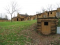 Gunpowder Magazine at Fort Harrod
 -
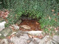 Spring at Fort Harrod
 -
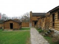 Cabins inside Fort Harrod
 -
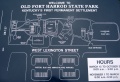 Map of Old Fort Harrod State Park


[[Category:Kentucky All}}