Fort Bowyer
|
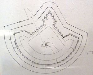
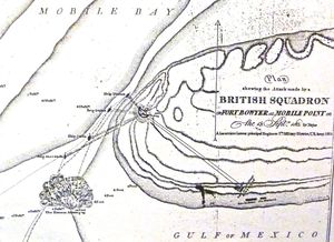
Fort Bowyer (1813-1822) - A U.S. Army Second System coastal fort established by Colonel John Bowyer in 1813 during the War of 1812 on Mobile Point in present day Baldwin County, Alabama. Named for Colonel John Bowyer. Destroyed by a storm 1821 and overbuilt by Fort Morgan (1). Sometimes seen in print, erroneously: "Fort Boyer". HistoryIn 1813 Mobile Point was occupied by U.S. forces under Colonel John Bowyer after it was abandoned by small Spanish garrison on the point. Colonel Bower built out a small coastal fort that was garrisoned in August 1814 by Major William Lawrence, 2nd U.S. Infantry and 161 men. The fort was constructed of sand and logs with a semicircular face toward the narrow Mobile Bay ship channel. The land side had a central bastion flanked by two demi-bastions. A magazine was located in the center of the fort. The semicircular face was some 400 feet long with 60‑foot sides connecting it to the land side bastion. The fort was about 180 feet deep from the parapet to the tip of the land side bastion. Reports of the fort's armament range from 6 to 20 cannons from Fort Charlotte mounted on an open parapet (no casemates). The post, manned by 120 regular troops commanded by Maj. William Lawrence of the United States Army, was unsuccessfully attacked by the British on 12-16 September 1814 on their way to the Battle of New Orleans. On their return trip in February 1815, it was captured by the British after a 5‑day land and sea siege. The post was returned to U.S. control after the British learned the Treaty of Ghent had been ratified. Fort Bowyer was severely damaged by a storm in September 1821 and abandoned as its Third System replacement, Fort Morgan, was being built. Current StatusNo remains, site located in Fort Morgan State Park, Baldwin County, Alabama USGS Geographic Names Information System (GNIS) Database Entry: 156368
Sources:
Links:
Visited: 23 Dec 2011
| ||||||

