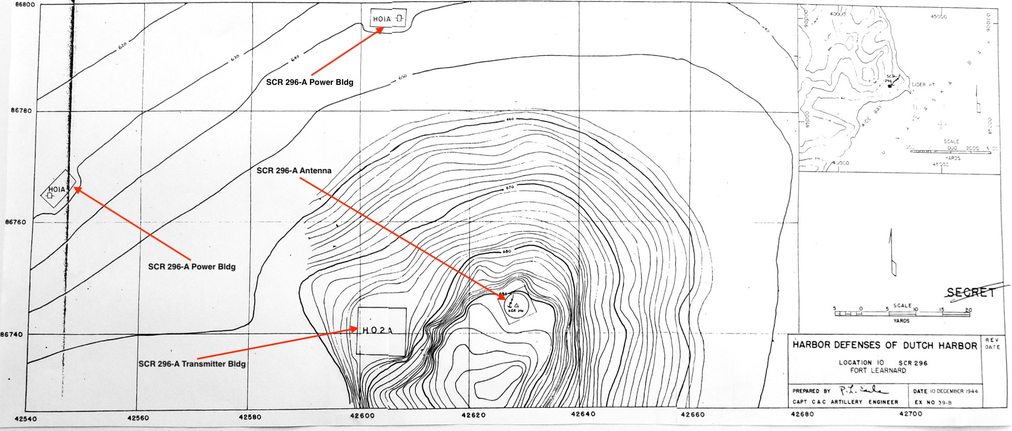
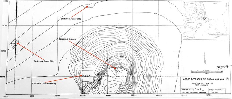
File:Elder Point WWII Radar Site Plan.jpg
Elder Point WWII Radar Site Plan (Annotated), public domain,
- U.S.Army, Supplement to the Harbor Defense Project Harbor Defenses of Dutch Harbor, (SRHDDH), 1944, CDSG
File history
Click on a date/time to view the file as it appeared at that time.
| Date/Time | Thumbnail | Dimensions | User | Comment | |
|---|---|---|---|---|---|
| current | 01:22, 25 January 2019 | | 2,000 × 853 (395 KB) | John Stanton (Talk | contribs) | Elder Point WWII Radar Site Plan (Annotated), public domain, {{HBSuppDutch HarborWWII}} |
- Edit this file using an external application (See the setup instructions for more information)
File usage
The following page links to this file:
Metadata
| Camera manufacturer | samsung |
|---|---|
| Camera model | SM-G955U |
| Exposure time | 1/33 sec (0.030303030303) |
| F Number | f/1.7 |
| ISO speed rating | 160 |
| Date and time of data generation | 11:25, 24 January 2019 |
| Lens focal length | 4.25 mm |
| Orientation | Normal |
| Horizontal resolution | 72 dpi |
| Vertical resolution | 72 dpi |
| Software used | Photos 3.0 |
| File change date and time | 11:25, 24 January 2019 |
| Exposure Program | Normal program |
| Exif version | 2.2 |
| Date and time of digitizing | 11:25, 24 January 2019 |
| Meaning of each component |
|
| APEX shutter speed | 5.044 |
| APEX aperture | 1.53 |
| APEX brightness | 1.08 |
| APEX exposure bias | 0 |
| Maximum land aperture | 1.53 APEX (f/1.7) |
| Metering mode | Center weighted average |
| Light source | Unknown |
| Flash | Flash did not fire |
| User comments | JKJK�
???��!���??���?����������������������������������?�?�.�??������??��??��?[??k���????yd��?????���k�????��@"��A"��A"��A"��A"��A"��A"��@"��@"��@"��@"��0"��0"��0"��0"�� "��0"��0"��@"��@"��@"��@"��@"��@"��@"��@"��0"�� "�� "���������� "��0"��0"��@"��@"��@"��@"��@"��P"��@"��@"��0"�� "�������������� "��@"��0"��0"��@"��@"��@"��@"��P"��@"��@"��?���?��������������� "��@"��0"��0"��@"��@"��@"��P"��P"��P"��P"��@"��?���?���?������� "��@"��0"��@"��@"��@"��@"��P"��P"��`3��P"��@"��?���?���?������� "��@"��0"��@"��@"��@"��P"��P"��`3��`3��P"��P"��?���?���?���?��� "��@"��0"��@"��@"��@"��@"��P"��`3��`3��P"��?���?���?��� "��?��� "��@"��@"��@"��@"��@"��P"��P"��P"��?���?���?���?���?���?���?��� "��@"��@"��@"��@"��@"��P"��P"��`3��?���?���?���?���?���?���?���?���@"��@"��@"��@"��@"��P"��P"��`3��?���?���?���?���?���?���?���?���@"��0"��@"��@"��@"��@"��?���P"��?���?���?���?���?���?���?���?���@"��@"��@"��@"��@"��P"��P"��?���?���?���?���?���?���?���?���@"��@"��@"��@"��@"��@"��@"��@"��@"��@"��@"��@"��@"��@"��0"��0"��@"��A"��A"��A"��A"��@"��@"��@"��@"��@"��@"��@"��@"��@"��@"��@"��@"��@"��A"��@"��A"��A"��A"��@"��@"��@"��@"��@"��@"��@"��@"��@"��@"������?�?�?�?�?���?�������������������������������������������?�?�w�?�?�v�?�?�v�?�?�v�?�?�v�?�?�v�?�?�v���������������������������������?���?�����?�����?�j�?�?�?�?�?�?�?�?�?���?�?���?�?���?�������������������������������������������������������?�?�w�?�����?>������??��������L�����������������������������������������������������������������������������3}��??������������������������������������������������������������������������������������������������������������FAFA��?�?�q���?�(���??3�����FAFA(�?�??w�??v���???�?�??w�??v���???�?�$�b�??v���???�?�$�b�??v���???�?�$�b�??v���???�?���Z���v���???�?���Z���v���???�?���Z���v���???�?�????D�v���???�?�????D�v���???�?�????D�v���???�?�????R�v���???�?�????R�v���???�?�????R�v���???�?�???�b�v���???�?�???�b�v���???�?�???�b�v���???�?�?????�v���???�?�?????�v���???�?�?????�v���???�?�??????v���???�?�??????v���???�?�??????v���???�?�??��??v���???�?�??��??v���???�?�K�????v���???�?�K�????v���???�?�K�????v���???�?�:�????v���???�?�:�????v���???�?�:�????v���???�?�????��v���???�?�????��v���???�?�????��v���???�?���&�?�v���???�?���&�?�v���???�?���&�?�v���???�?�??(�*�v���???�?�??(�*�v���???�?�??(�*�v���???�����?��? �����?�~�?�^�FAFA����������������������������������������������������������������������������������������������������������?�?�����?�?�����?�(�����?�?�����?�?�����?�?�����?�������?�?�����?�?�����?�?�����?�?�����?�?�����?�^�����?�?�����?�?�����?�?�����?�?�����?�?�����?�?�����?�?�����?�?�����?�?�����?�?�����?�?�����?�?�����?�?�����?�?�����?�?�����?�?�����?�?�����?�?�����?�?�����?�?�����?�?�����?�?�����?�?�����?�?�����?�?�����?�?�����?�?�����?�?�����?�?�����?�?�����?�?�����?�?�����?�?�����?�?�����?�?�����?�?�����?�?�����?�?�����?�?�����?�?�����?�?�����?�?�����?�?�����?�?�����?�?�����?�?�����?�?�����?�?�����?�?�����?�?�����?�?�����?�?�����?�B�����?�`�����?�?�����?�������?�?�����?�?�����?�?�����?�?�����?�?�����?�?�����?�?�����?�?�����?�?��� �2� ��� �^� �����?�������]�������?���������������?�������?������������� �2� �����?����� �t� �����?������������������������������������������������������������������������������������������������������������� � ���?�?���?�������������������������������������������������?????�������]���������������1�?r����[ ��J ��:���J��������������������������������������������������������������������F���F������������������?�������%�����������������������������������������������������������t���R���?���Z ������[ ��?��������������� ���?���!�����������������������????#�����������������������������������������������������������������������������������������������n���?�������n���������������? ��Y ��? ����������????{�����������~ ��? �� ��? ��Y ��a ��e ��u ��? ��} ��? ��? ��Q ��D ��X ��g ��y ��y �� ��? ��> ��A ��7 ��N ��_ ��j ��r ��x ��? ��? ��? ��D ��2 ��Q ��I ��\ ��d ��o ��? ��? ��6 ��7 ��J ��& ��> ��G ��Y ��? ��% ��� ��? ��9 ��> ��4 ��K ��| ��� ��? ��? ��7 ��� ��$ ��D ��f ��� ��# ��. ��9 ��2 ��? ���������������J��????` ��[ ������ �������������������? ��? ��� ����������? ���"���(���3���D���F������V???�����������������������������������������������������������������������?���????������������������������/ ��[ �������L���������� ���????????????????����????���������������������������� �������[ ������????W �� ��� ���b����������������������������������������������������������������������������������? ��????????����������������? ������, ��? ���������������F���J���L������������������ ���d����;�����������������������������������<����������������������������������?&������������������������������������������������������������������������������������������������������������������������������������������������������������������������������������������������������������������������������������������������������������������������������������������������������������������ssdjag��������������������������ssldc��M???���������������������ssuniqueidh`3; "�`��3�����ssmtf�?�????�???��?�???���???��?�???��??????????????????????�SSCAL PF12QSKC0,222,401FFC1FC1S12�ssoisD84KA02 D84KA02 D84KA02 0 |
| Supported Flashpix version | 0,100 |
| Color space | sRGB |
| Sensing method | One-chip color area sensor |
| Scene type | A directly photographed image |
| Exposure mode | Auto exposure |
| White balance | Auto white balance |
| Focal length in 35 mm film | 26 mm |
| Scene capture type | Standard |
| IIM version | 2 |
| Short title | Elder Point WWII Radar Site Plan |